Why Accurate Elevation Data Matters for Cell Tower Placement
Accuracy, resolution and currency have significant impacts on the outcome of RF modeling for 5G network topology.
3/14/20253 min read
Understanding 5G Technology and Terrain Interference
5G technology marks a major advancement in mobile communication, greatly improving data transmission when High-Band frequencies in the range of 24-100GHz are used. High-band frequencies imply millimeter wavelengths (mmWave) which offering much faster data rates compared to previous generations at a cost of range and attenuation.
mmWave frequencies are ideal for urban areas with high data usage, enabling applications like ultra-high-definition video streaming, virtual reality, and seamless IoT device operation. However, these frequencies have a shorter range and can be easily blocked by obstacles like buildings and vegetation, requiring strategic antenna placement for consistent coverage.
Precise elevation data is crucial for optimizing 5G networks. Antennas must be placed to maximize line of sight and minimize obstructions, improving signal quality and reliability. Understanding mmWave behavior and using accurate elevation data is essential for effective antenna deployment. As 5G evolves, these elements remain critical.
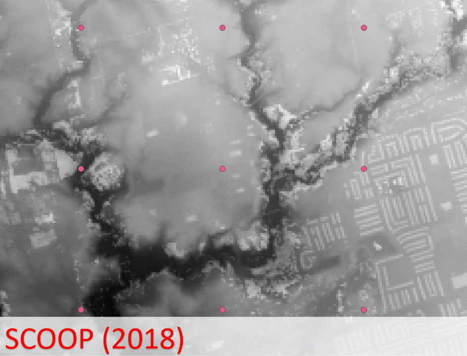
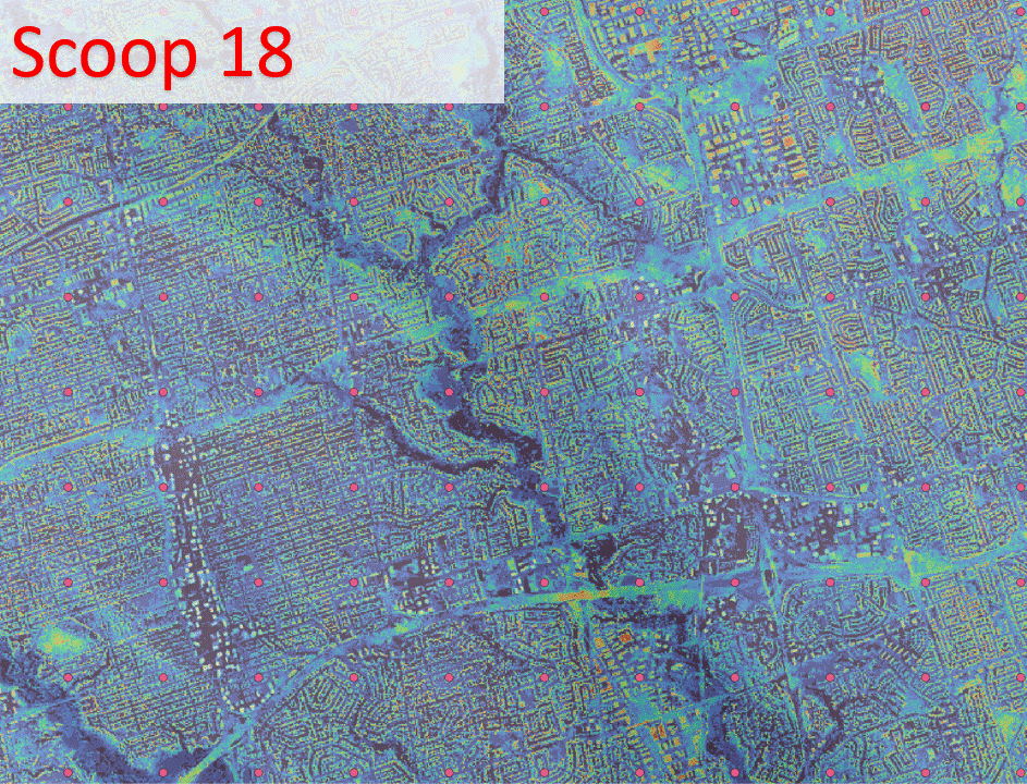
The elevation model below is from SCOOP and is ideal for modeling. It is very high resolution (16cm) and covers South Central Ontario. Captured in 2018 and 2019 it was released to the public in 2023.
The Role of Elevation Data in Antenna Placement
Accurate, current and high resolution elevation data is crucial for effective 5G antenna placement.
Height data including first surface features such as buildings in addition to terrain influence signal propagation, especially for High-Band frequencies which have an effective maximum range of ~600m.
Elevation data including first surface features such as buildings and vegetation helps planners position antennas above obstructions and select sites for enhanced coverage.
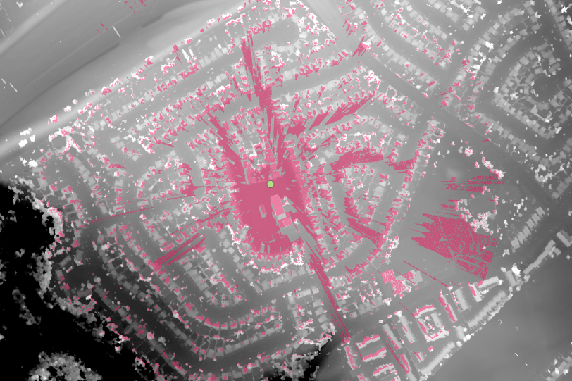
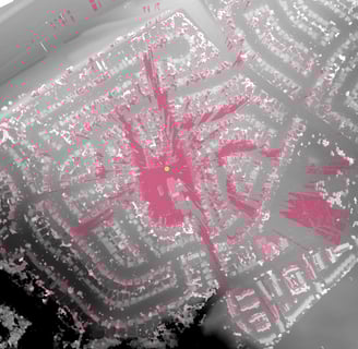
This example illustrates the line of sight or viewshed from a 30m high tower (green dot) placed in a school yard. Given the high signal attenuation, it becomes clear that deploying High-band 5G coverage within a single neighborhood requires significant planning.
Challenges in Gathering Accurate Elevation Data
Obtaining reliable elevation data is crucial for deploying 5G mobile antennas effectively. However, this process is hindered by outdated or inaccurate geographic databases of elevation data (DEMs), leading to suboptimal antenna placement and affecting network performance. Urban environments, with their complex structures like tall buildings and bridges, further complicate elevation assessment and signal propagation.
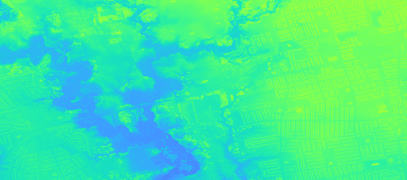
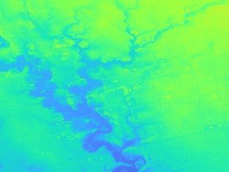
The example below illustrates the different outcomes based on the accuracy of the source DEM. A uniform grid of cell towers spaced 1km apart at a height of 30m radiating a maximum distance of 2km is used to determine the direct line of sight coverage to every location in the Don Valley (Toronto, Canada). The color scale ranges from blue (0 coverage) to red (14 towers covering).
Datasets:
SCOOP: Very high resolution (16cm), collected 2018-2019 and represents terrain and buildings very precisely.
COP30: Coarse resolution (30m), collected 2011-2015 and represents terrain and large buildings accurately.
Sentinel-1: Medium resolution (14m), collected 2024 and represents terrain and buildings accurately
Observations
Red indicates greater cellular coverage, but only if the elevation model is accurate. In this case the modeling based on COP30 is flawed because most buildings are missing from the elevation model (DEM). SCOOP is the most accurate source and obstructions from buildings are clearly visible. The Sentinel-1 derived DEM results align well with SCOOP indicating a better measure of the first surface features such as buildings.
DEM accuracy inclusive of first surface features is critical in the placement and ongoing maintenance of a 5G network topology.
Sentinel-1 derived DEMs show accurate coverage where precision DEMs are unavailable or are outdated.
Current Elevation Data is Crucial
Traditional surveying methods often fall short in these settings, necessitating real-time elevation updates. Fast growing urban environments require ongoing updates to the DEMs used geographic databases.
The example below illustrates the different outcomes based on the currency of the source DEM. A new subdivision has been added in Richmond Hill (Toronto, Canada) since 2018. A comparison of SCOOP, created in 2018, and the Sentinel-1 derived DEM, created in 2024, illustrates the difference in expected 5G coverage. Using SCOOP would provide a false estimate of coverage.