
Understanding Population Growth in Benin City, Nigeria: Comparing Estimates with Satellite Data
A comparison of population growth rates with geospatial changes estimated using Sentinel-1 InSAR proves accurate to 0.02%
2/7/20256 min read


Validation of Population Growth in Benin City, Nigeria
Benin City, located in southern Nigeria, has a rich history marked by significant demographic changes influenced by various socio-economic factors. The population trends in this city can be better understood through historical census data, which highlight pivotal moments that shaped its growth. According to the 1952 census, the city's population was estimated at approximately 131,000. Currently it is estimated that the population at the end of 2024 is
1,972,560 and is estimated to have grown at an average rate of 3.31% per year for the past 5 years.
Several factors are driving this growth rate, including a high fertility rate, rural-to-urban migration, and improvements in living conditions. The urban expansion of Benin City also fostered the growth of informal settlements, significantly affecting population density and demographic composition. The city's population dynamics continue to evolve, reflecting changes in socio-economic circumstances, which make it essential to explore these trends for future planning and development.
Traditional methods of estimating population growth utilize census and survey data which may result in error. One promising method to validate growth estimates is through the use of satellite based reconnaissance of the area over varying time periods. Employment of numerical models which factor in the expansion and densification of an urban area can be used to confirm population growth estimates. The following study illustrates that simple basic geospatial measurements can be employed which show a very strong correlation with population growth estimates for Benin City.
Current Methods of Estimating Population Growth
Estimating population growth in Benin City, Nigeria, involves several methods employed by regional and international organizations, each contributing to a comprehensive understanding of demographic trends. A primary method is the collection and analysis of census data, which provides a snapshot of the population at a specific time. In Nigeria, national population censuses are conducted periodically, and the latest census data serves as a vital reference point for population estimates. This data includes demographic variables such as age, gender, and socio-economic status, which are essential for understanding growth patterns.
Another important method is conducting surveys, which allow for more targeted inquiry and can provide information on specific population segments that may not be adequately captured during standard census operations. Surveys, such as demographic and health surveys, focus on key variables that affect population change, including fertility rates, mortality rates, and migration patterns. These surveys often involve statistical sampling techniques to gather data that can then be extrapolated to estimate broader population trends in Benin City.
In addition to census data and surveys, demographic projections play a crucial role in estimating future population growth. These projections utilize current and historical data to forecast population changes based on observed trends. Factors such as birth rates, death rates, and migration rates are analyzed to create models that predict how the population of Benin City may evolve over the coming years. While these methods provide valuable insights, the reliability of the estimates can be affected by various challenges, particularly in urban settings where data collection can be hindered by accessibility issues, logistical constraints, and rapid population changes.
Overall, the combination of census data, surveys, and demographic projections offers a multi-faceted view of population growth in Benin City, yet it is essential to recognize the limitations and challenges organizations face in ensuring data accuracy.
Role of Geospatial Data in Validating Population Estimates
Geospatial data, increasingly harnessed from satellite technology, plays a critical role in understanding and validating population trends in urban settings such as Benin City. By providing accurate spatial information, this technology permits researchers and urban planners to obtain reliable demographic insights, thereby validating and refining population estimates and facilitating informed decisions regarding urban development.
One significant advantage of utilizing geospatial data lies in its ability to confirm historical population growth rates through spatial analysis. By examining changes in land use, infrastructure development, and settlement patterns over time, urban planners can derive a clear picture of demographic shifts. For instance, satellite imagery can reveal the expansion of built-up areas, indicating potential population increases that might not be reflected in traditional census methods. This approach was successfully applied in regions like Lagos, Nigeria, where researchers used satellite data to track urban sprawl and correlate it with population density fluctuations.
Moreover, geospatial data provides granular insights that can inform effective urban planning. Understanding population distribution in real time enables planners to identify areas that require services and infrastructure investment, establishing a foundation for strategic resource allocation. For instance, by analyzing satellite data, planners can pinpoint neighborhoods with inadequate access to utilities and health services, ultimately leading to a more comprehensive urban strategy that addresses the unique needs of the population.
The effectiveness of geospatial data is evident in various global contexts, such as Northern Uganda, where satellite imagery successfully assisted in mapping settlement patterns and population movements after internal displacement. Similarly, the application of this technology in Benin City can enhance the accuracy of population estimates, enabling the city to better adapt to the challenges posed by rapid urbanization. Ultimately, the integration of geospatial data not only aids in validating current demographic metrics but also lays the groundwork for sustainable urban growth in the future.
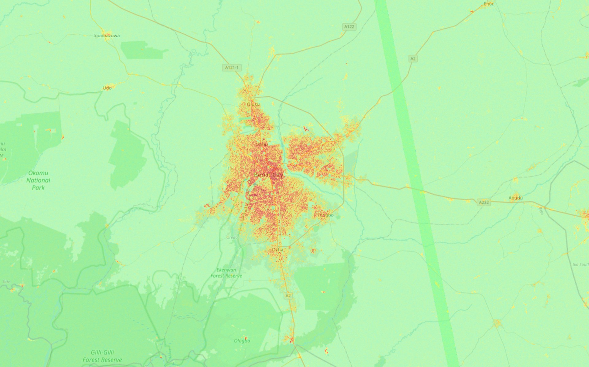
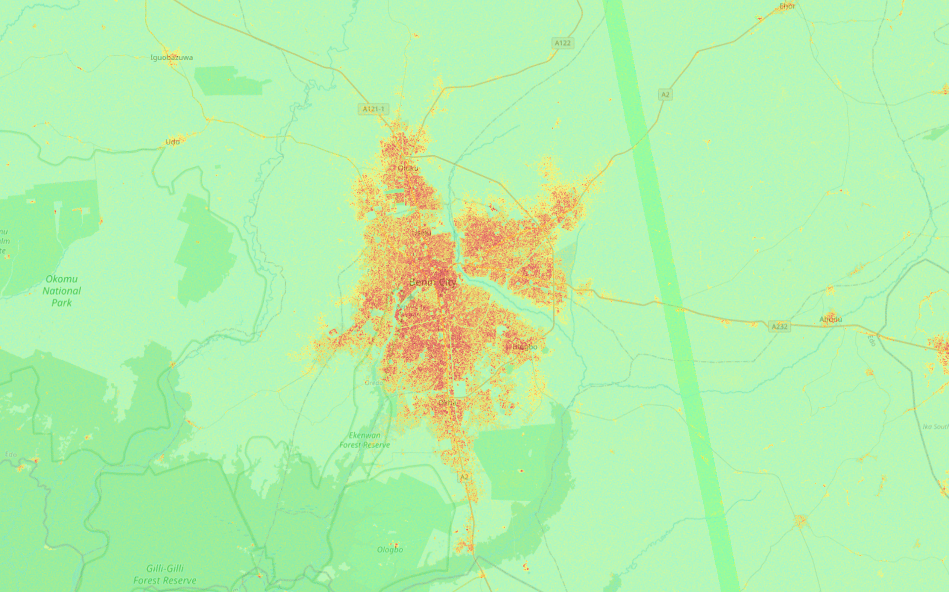
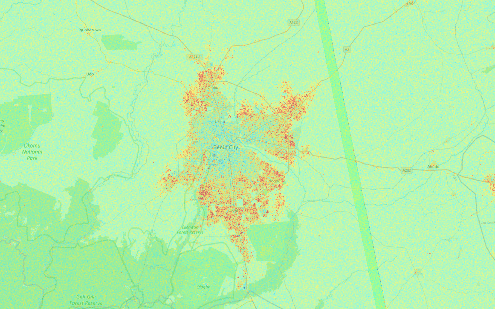
Changes in the spatial extent and density between 2019 and 2024 in Benin City, Nigeria as shown using Sentinel-1 Radar Imagery and InSAR derived elevation changes
Population Growth Estimate Using Geospatial Estimation
Benin City continues to grow rapidly and the last census performed in 2022 estimated the population to be 1,841,000. Over the past 5 years the population growth rate to be 3.31%. Confirming this number remotely and identifying where the city is experiencing rapid growth can prove valuable for the development of supporting infrastructure such as roads social services.
Using the Sentinel-1 satellite constellation it is possible to generated timely geospatial data that identifies changes in land use along with the addition and removal of manmade structures.
The following images display elevation changes calculated using Sentinel-1 SAR images over the year's of 2019 and 2024.
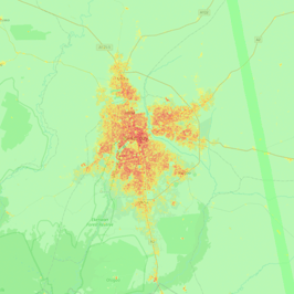
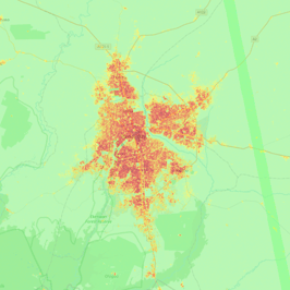
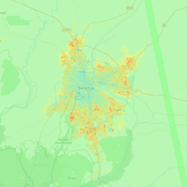
Figure 1. height changes 2019, Figure 2. height changes 2024, Figure 3. Difference (2024 subtract 2019)
The following demonstrates a potential method to determine the rate of growth from 2019 to 2024 for Benin City to determine if a correlation can be made with census based growth estimates.
Hypothesis
Measuring new features on top of existing terrain will correlate with population growth in Benin City.
Methodology
Create elevation change maps relative to the Copernicus DEM (COP30) within Benin City for the years of 2019 and 2024. (See figures above)
Calculate the sum of pixels where the elevation has been raised by more than 1 meter for the 2019 and 2025 elevation changes maps respectively.
Compare the growth in urban area with the estimated population growth for Benin City as published by the World Population Review.
In 2020 the population was estimated to be 1,727,170.
In 2021 the population was estimated to be 1,782,000. A growth rate of 3.17%.
In 2022 the population was estimated to be 1,841,080. A growth rate of 3.32%.
In 2023 the population was estimated to be 1,904,630. A growth rate of 3.45%.
In 2024 the population was estimated to be 1,972,560. A growth rate of 3.57%.
Note: It is assumed that the population estimate is at the end of each year.
Results:
In the composite elevation change map for the year January 1, 2019 - January 1, 2020 the number of pixels exceeding 1m above the Copernicus DEM (COP30) baseline elevation was 2,823,835 where each pixel is approximately 14m x 14m.
Extrapolating the expected area using the the estimated population growth rate for 2021 until the end of 2024 the expected area in pixels of Benin City is:
2021: 2,909,962 pixels. A growth rate of 3.17%.
2022: 3,002,208 pixels. A growth rate of 3.32%.
2023: 3,101,881 pixels. A growth rate of 3.45%.
2024: 3,208,896 pixels. A growth rate of 3.57%.
The measured number of pixels in the composite elevation change map for the year January 1, 2024 - January 1, 2025 was 3,208,152 pixels.
Comparing the measured growth of Benin City with the extrapolated projected area based on population growth the measurement was found to be within 0.02% of the expected value.
These results are extremely encouraging but neglect to account for industrial growth, the addition of multistory buildings and other sources of error so testing over further regions should be performed.
Implications of Population Growth for Urban Planning and Development
The rapid population growth in Benin City, presents significant implications for urban planning and development. As the population increases, the demand for adequate housing intensifies, leading to overcrowding in existing residential areas. With the current growth rate, it has become paramount for city planners to prioritize the development of affordable housing projects that can accommodate the rising number of inhabitants. This necessitates a comprehensive approach to zoning regulations and land use planning to ensure that new developments meet the needs of the population without overwhelming existing infrastructure.
In addition to housing, the expansion of infrastructure is a critical concern. A burgeoning population puts immense pressure on transportation networks, utilities, and public services. Roads, public transport systems, water supply, and sanitation services must be upgraded or expanded to avoid congestion and to improve the quality of life for residents. Failing to address these needs may lead to inefficiencies and systemic challenges that hinder urban development, resulting in increased socioeconomic disparities within the city.
Service delivery is another area that demands attention. With more residents comes an increased need for educational facilities, healthcare services, and recreational spaces. Urban planners must leverage demographic and geospatial data to assess the current and future needs of the population. By doing so, they can identify areas that require immediate investment, thereby promoting balanced development throughout Benin City.
Strategies such as public-private partnerships can play a pivotal role in enhancing urban infrastructure and services. Encouraging community involvement in urban planning can also foster sustainable development practices. Ultimately, addressing the challenges posed by population growth in Benin City requires a collaborative and multifaceted approach, ensuring that the city evolves into an accommodating and thriving urban environment for all residents.